(Image from PAGASA)
MANILA – Super Typhoon Betty continues to move closer to Luzon and will bring some rains and strong winds in parts of the country on Saturday.
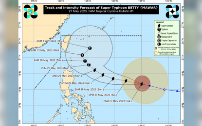
In its 4 a.m. weather bulletin, the Philippine Atmospheric, Geophysical and Astronomical Services Administration (PAGASA) said the center of the eye of Betty was estimated at 1,345 km. east of Central Luzon, packing maximum sustained winds of 195 kph near the center and gustiness of up to 240 kph, moving west-northwestward at 25 kph.
Cloudy skies with scattered rain showers and thunderstorms will prevail over Palawan, the Visayas, Zamboanga Peninsula, Northern Mindanao, and Caraga, brought by the trough of Betty and the southwesterly wind flow.
Metro Manila and the rest of the country will experience partly cloudy to cloudy skies with isolated rain showers or thunderstorms brought by the southwesterly wind flow and localized thunderstorms.
Betty is forecast to remain a super typhoon over the weekend and is seen to weaken faster beginning Monday or Tuesday during its slowdown period.
It is expected to bring heavy rainfall over Northern Luzon, especially the northern and western portions, on Monday through Wednesday.
Betty may also enhance the southwest monsoon, bringing heavy rainfall over the western portions of Southern Luzon and the Visayas on Monday. (PNA)
