PAGASA weather specialist Obet Badrina (Screengrab from PAGASA Facebook live video)
MANILA – There is only a slim chance that a tropical cyclone will develop or enter the Philippine Area of Responsibility (PAR) this week, a forecaster said Wednesday.
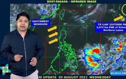
Outside PAR, Tropical Storm Lan (international name) was last tracked 2,670 km. east-northeast of extreme Luzon.
"We are not expecting it to enter PAR," Philippine Atmospheric, Geophysical and Astronomical Services Administration (PAGASA) forecaster Obet Badrina said in the agency's 5 a.m. bulletin, adding that Lan may head towards Japan.
Cloud clusters were monitored east of Mindanao but these are unlikely to develop into a tropical cyclone, he said.
"For the whole week, there is a slim chance that a tropical cyclone will enter or develop," he added.
Badrina noted that most areas in the country would experience warm weather on Wednesday, especially in the afternoon.
Thunderstorms are forecast in the afternoon.
The southwest monsoon will cause scattered rain showers and thunderstorms over Ilocos Norte, Ilocos Sur, Abra and Benguet.
These areas may also experience flooding or landslides due to moderate to heavy rains.
The rest of the country will have isolated rain showers caused by localized thunderstorms.
Meanwhile, extreme Northern Luzon continues to experience strong winds and rough seas.
The northern seaboard of Northern Luzon will have rough to very rough seas, so fishing boats and other small vessels are advised not to venture into the sea. Larger vessels are alerted against big waves.
Moderate to strong winds and moderate to rough seas will prevail over the rest of Luzon.
Elsewhere, winds will be light to moderate with slight to moderate seas, PAGASA said. (PNA)
