(Courtesy of PAGASA)
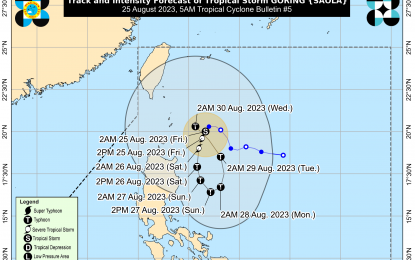
MANILA – Tropical Cyclone Wind Signal (TCWS) No.1 has been hoisted in four areas as Tropical Storm Goring (International name: Saola) slightly intensified near Batanes, the weather bureau said Friday.
The Philippine Atmospheric, Geophysical and Astronomical Services Administration (PAGASA) said that as of 3 a.m., Goring was estimated at 220 km. east-southeast of Basco, Batanes with maximum sustained winds of 75 kph near the center and gusts of up to 90 kph.
Signal No. 1 has been hoisted in Batanes, the eastern portion of Babuyan Islands (Babuyan Islands, Camiguin Island), the eastern portion of mainland Cagayan (Santa Ana, Gonzaga, Lal-Lo, Gattaran, Baggao, Peñablanca), and the northeastern portion of Isabela (Maconacon, Divilacan, Palanan).
According to PAGASA, the trough of Goring will bring cloudy skies with scattered rain showers and thunderstorms in Cagayan Valley, the Cordillera and Ilocos regions, which may cause possible flooding or landslides due to moderate with at times heavy rains.
Meanwhile, Palawan, Occidental Mindoro, Zambales, and Bataan will have cloudy skies with scattered rain showers and thunderstorms due to the southwest monsoon or “habagat.”
Metro Manila and the rest of the country will experience partly cloudy to cloudy skies with isolated rain showers or thunderstorms due to the southwest monsoon or localized thunderstorms.
Extreme Northern Luzon will experience moderate to strong winds, with moderate to rough seas, while the rest of the country will have light to moderate winds with slight to moderate seas.
In the meantime, Goring is forecast to move slowly south-southwestward or southward over the waters east of Northern Luzon until Saturday afternoon, before turning southeastward for the rest of Saturday through Sunday afternoon.
The tropical cyclone will then loop northward before turning northwest on Tuesday towards the Luzon Strait.
PAGASA forecast Goring to rapidly intensify, noting that it could reach typhoon category by Saturday, possibly reaching its peak intensity on Sunday evening. (PNA)
