Courtesy of PAGASA
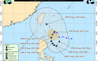
MANILA – Tropical Cyclone Wind Signal (TCWS) No.1 has been hoisted in additional areas of Cagayan and Isabela as Goring (International Name: Saola) intensified into a severe tropical storm near Cagayan, the weather bureau said Friday.
The Philippine Atmospheric, Geophysical and Astronomical Services Administration (PAGASA) said that as of 5 p.m., the center of Goring was estimated at 260 kilometers east of Calayan, Cagayan with maximum sustained winds of 110 kilometers per hour (kph) near the center with gusts of up to 135 kph, and moving slowly southeastward.
Signal No. 1 has been hoisted over Batanes, the eastern portion of Babuyan Islands (Babuyan Is., Camiguin Is.); the eastern portion of mainland Cagayan (Santa Ana, Gonzaga, Lal-lo, Gattaran, Baggao, Peñablanca, Santa Teresita, Buguey, Camalaniugan, Aparri); and the eastern portion of Isabela (Maconacon, Divilacan, Palanan, Dinapigue, San Mariano, San Pablo, Cabagan, Tumauini, Ilagan City).
Heavy rainfall and gusty winds will be felt over Batanes, Cagayan and Isabela, PAGASA said.
Meanwhile, the trough of STS Goring will bring cloudy skies with scattered rain showers and thunderstorms over the rest of Cagayan Valley, Cordillera Administrative Region and Ilocos Region.
The southwest monsoon or “habagat” affecting Central and Southern Luzon, the Visayas, and Mindanao will also bring cloudy skies with scattered rain showers and thunderstorms over Palawan, Occidental Mindoro, Zambales and Bataan.
Metro Manila and the rest of the country will have partly cloudy to cloudy skies with isolated rain showers or thunderstorms due to the prevailing habagat or localized thunderstorms.
PAGASA said extreme Northern Luzon will experience strong winds with rough seas, while the rest of the country will have light to moderate with slight to moderate seas. (PNA)
