(Photo courtesy of PAGASA)
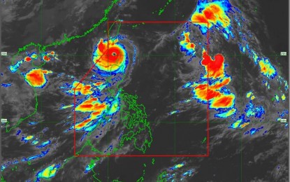
MANILA – Rains and gusty winds will continue to prevail as Super Typhoon Goring heads towards the northern portion of the West Philippine Sea, the weather bureau said Wednesday.
In its 8 a.m. bulletin, the Philippine Atmospheric, Geophysical and Astronomical Services Administration (PAGASA) said Goring was last tracked 90 km. west-southwest of Basco, Batanes, and is forecast to exit the Philippine Area of Responsibility either on Wednesday night or Thursday.
Goring packs maximum sustained winds of 195 kph near the center and gustiness of up to 240 kph.
Tropical Cyclone Wind Signal (TCWS) No. 3 remains hoisted over Batanes and the northern and western portions of the Babuyan Islands (Babuyan, Calayan and Dalupiri Islands), and signal No. 2 over the rest of the Babuyan Islands, the northern portion of Ilocos Norte (Pagudpud, Adams, Bangui, Dumalneg and Burgos) and the extreme northwestern portion of mainland Cagayan (Santa Praxedes, Sanchez-Mira, Claveria, Pamplona and Abulug).
Signal No. 1 has been hoisted over the northern and central portions of Cagayan (Solana, Tuao, Iguig, Amulung, Santo Niño, Piat, Rizal, Lasam, Gattaran, Santa Ana, Gonzaga, Lal-Lo, Santa Teresita, Buguey, Baggao, Alcala, Camalaniugan, Aparri, Allacapan and Ballesteros), Apayao, the northern portion of Kalinga (Balbalan and Pinukpuk), the northern portion of Abra (Tineg, Lagayan, Lacub, Malibcong, San Juan, Danglas, La Paz, Dolores, Bangued, Lagangilang and Licuan-Baay), the rest of Ilocos Norte and the extreme northern portion of Ilocos Sur (Sinait, Cabugao, San Juan and Magsingal).
Stormy weather will prevail over Batanes and northeastern Cagayan, including the Babuyan Islands, while rains with gusty winds are likely over Ilocos Norte, Apayao and the rest of mainland Cagayan.
The enhanced southwest monsoon will cause monsoon rains over Zambales, Bataan, Occidental Mindoro and the northern portion of Palawan; and occasional rains over Metro Manila, the rest of the Ilocos Region, the rest of Mimaropa, Tarlac, Pampanga, Bulacan, Cavite and Batangas.
It will also cause scattered rain showers and thunderstorms over the rest of Luzon, the rest of Western Visayas and the Zamboanga Peninsula.
The rest of the country will have isolated rain showers caused by localized thunderstorms, PAGASA said.
Rough to very rough seas remain likely over the seaboards of Luzon, the Visayas and the eastern seaboard of Mindanao, it said.
56.4K families so far affected
In its latest bulletin, the National Disaster Risk Reduction and Management Council (NDRRMC) announced that families affected by Typhoon Goring have now climbed to 56,410, significantly higher than the 19,370 families reported on Tuesday.
This figure is equivalent to 196,926 persons residing in 832 barangays in Ilocos region, Cagayan Valley, Central Luzon, Calabarzon, Mimaropa, Western Visayas and the Cordillera Administrative Region (CAR).
Of this number, 9,508 families or equivalent to 35,095 persons are being aided in 376 evacuation centers while another 3,407 families or around 13,902 individuals are being assisted on the outside.
The Office of Civil Defense earlier said the affected families include those displaced and those not needing transfer or removal from their residence.
Houses damaged were placed at 134 and these were reported in six regions. (with Priam Nepomuceno/PNA)
