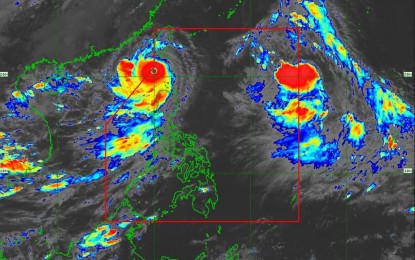
(Grabbed from PAGASA's Facebook page)
MANILA – Severe Tropical Storm Haikui, which could possibly enter the Philippine Area of Responsibility (PAR) on Wednesday night, is likely to remain far from the landmass, the weather bureau said.
In its 5 p.m. forecast, the weather bureau said Haikui was last tracked 1,465 kilometers east of extreme Northern Luzon. Once inside PAR, it will be named Hanna.
While Hanna may reach the typhoon category on Friday, the weather bureau said it is less likely to affect the country. However, it will enhance the southwest monsoon, resulting in occasional or monsoon rains over the western portion of Luzon and the Visayas throughout the week.
It is also expected to exit PAR on Friday.
Meanwhile, Super Typhoon Goring has maintained its strength as it is about to exit PAR either tonight or Thursday. It packs 195 kph near the center and gustiness of up to 240 kph, and was last located 185 km. west of Itbayat, Batanes.
Tropical cyclone wind signal No. 1 remains hoisted over Batanes, Babuyan Islands, Ilocos Norte, northern portion of Apayao (Luna, Santa Marcela, Calanasan), and the northwestern portion of Cagayan (Pamplona, Claveria, Ballesteros, Abulug, Sanchez-Mira, Santa Praxedes).
Goring continues to enhance the southwest monsoon, causing gusty conditions over the following areas not under signal No. 1, especially in coastal and upland/mountainous areas exposed to winds: Ilocos Region, Cordillera Administrative Region, Metro Manila, Calabarzon, Mimaropa, Bicol Region, Western Visayas, Zambales, Bataan, Bulacan, and Aurora.
The southwest monsoon is still forecast to bring occasional or monsoon rains over the western portions of Luzon and the Visayas over the next three days.
Most seaboards of Luzon and the Visayas, and the eastern seaboard of Mindanao will continue to experience rough to very rough seas, the Philippine Atmospheric, Geophysical and Astronomical Services Administration (PAGASA) said.
The typhoon will cause scattered to widespread rain showers and thunderstorms over Batanes, Cagayan, including Babuyan Islands, Ilocos Norte and Apayao.
"There is a moderate to high risk of storm surge which may cause flooding in the low-lying and exposed coastal areas of Batanes and the northern and western portions of Babuyan Islands," PAGASA said. (PNA)
