MANILA – Severe Tropical Storm Hanna (international name Haikui), along with two other tropical cyclones outside the Philippine Area of Responsibility (PAR), is enhancing the southwest monsoon (habagat) that causes rain showers and gusty winds over parts of the country, the weather bureau said Thursday.
In its daily weather bulletin issued at 4 a.m., the Philippine Atmospheric, Geophysical and Astronomical Services Administration (PAGASA) said that as of 3 a.m., Hanna's center was observed 1,215 kilometers east of extreme Northern Luzon with maximum sustained winds of 95 kph near the center and gustiness of up to 115 kph.
Hanna is moving west northwest at 20 kph and is forecast to remain far from the landmass. It is unlikely to directly affect the country.
Hanna and the tropical cyclones outside PAR -- Saola (formerly Goring) and Tropical Storm Kirogi -- are all enhancing the habagat.
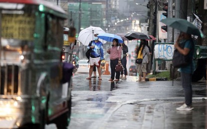
The habagat is forecast to bring occasional to monsoon rains over the western portion of Luzon in the next three days.
Forecast rainfall are generally higher in elevated or mountainous areas. Flooding and rain-induced landslides are expected, especially in areas highly susceptible to these hazards, PAGASA said.
Habagat will cause gusty conditions over the following areas, especially in coastal and upland/mountainous areas: Ilocos Region, Cordillera Administrative Region, Metro Manila, Region 4-A (Calabarzon), Region 4-B (Mimaropa), Bicol Region, Western Visayas, the northern portion of Eastern Visayas; Zambales, Bataan, Aurora and Bulacan,
No tropical cyclone wind signal was hoisted on any part of the country, and Hanna is less likely to cause rough sea conditions over any seaboard.
The southwest monsoon, however, will cause rough seas over most seaboards of Luzon and the Visayas.
Hanna is forecast to exit PAR on Friday, PAGASA said. (PNA)
