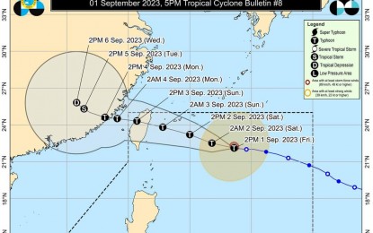
(Image grabbed from PAGASA's Facebook page)
MANILA – Typhoon Hanna has maintained its strength but is still unlikely to affect the country, although the enhanced southwest monsoon or "habagat" will continue to bring rains and gusty winds over a huge part of the archipelago.
In its 5 p.m. bulletin on Friday, the Philippine Atmospheric, Geophysical and Astronomical Services Administration (PAGASA) said Hanna is packing maximum sustained winds of 120 kph near the center and gustiness of up to 150 kph.
It was last tracked 710 km. east northeast of Itbayat, Batanes, and is forecast to exit the Philippine Area of Responsibility (PAR) on Sunday afternoon or evening.
No tropical cyclone wind signal was hoisted on any part of the country, but gusty conditions still prevail over Zambales, Bataan, Aurora, Bulacan, Batanes, Ilocos Region, Cordillera Administrative Region, Metro Manila, Calabarzon, Mimaropa, Bicol Region, Western Visayas, and the northern portion of Eastern Visayas.
The enhanced habagat also causes rough to very rough sea conditions in most seaboards of Luzon and Western Visayas, and the seaboard of Northern Samar.
"Habagat", being enhanced by two tropical cyclones outside PAR, continues to cause monsoon rains over Ilocos Region, Zambales, Bataan, and Occidental Mindoro.
Occasional rains due to "habagat" will prevail over Metro Manila, Calabarzon, Abra, Apayao, Benguet, Tarlac, Pampanga, and Bulacan.
Scattered rain showers and thunderstorms due to the southwest monsoon will be experienced over Cagayan Valley, the rest of the Cordillera Administrative Region, the rest of Central Luzon, the rest of Mimaropa, and Antique.
The rest of the country will have isolated rain showers caused by localized thunderstorms, PAGASA said. (PNA)
