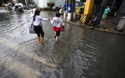
FLOODED. The corner of UN and Taft Avenues in Ermita, Manila is still flooded on Sunday morning (Sept. 3, 2023) as the southwest monsoon brings intermittent moderate to heavy rains. Typhoon Hanna and the enhanced southwest monsoon or "habagat" will bring rain showers and gusty winds over most parts of the country, the weather bureau said Monday (Sept. 4). (PNA photo by Joan Bondoc)
MANILA – Typhoon Hanna and the enhanced southwest monsoon (habagat) will bring rain showers and gusty winds over most parts of the country, the weather bureau said Monday.
Hanna was last tracked 265 kilometers northwest of Itbayat, Batanes. It packs maximum sustained winds of 120 km per hour near the center and gustiness of up to 150 kph.
Tropical cyclone wind signal No. 1 is still hoisted over Batanes, which may experience gusty winds, and moderate to heavy rains. Flash floods and landslides are possible.
The enhanced "habagat" will also bring gusty winds over Batanes, Babuyan Islands, Ilocos Region, Cordillera Administrative Region, Nueva Vizcaya, the southern portion of Aurora, Zambales, Bataan, Bulacan, Metro Manila, Occidental Mindoro, Romblon, Marinduque, the northern portion of Palawan including Calamian, Kalayaan, and Cuyo Islands and most of Calabarzon, Bicol Region, and Western Visayas.
Habagat is forecast to cause occasional monsoon rains over the western portion of Luzon and Antique in the next three days.
On Monday, monsoon rains will prevail over Pangasinan, Zambales, Bataan, and Occidental Mindoro, and occasional rains over Metro Manila, the rest of Ilocos Region, Apayao, Abra, Benguet, Tarlac, Pampanga, Bulacan, Rizal, Cavite and Batangas.
"Due to its ongoing erratic movement near the coast of Kaohsiung City, Taiwan, Typhoon Hanna is forecast to exit the PAR (Philippine Area of Responsibility) region within the next 6 to 12 hours," the Philippine Atmospheric, Geophysical and Astronomical Services Administration PAGASA said in its 5 a.m. bulletin.
Both Hanna and "habagat" will cause rough to very rough seas over the seaboards of Northern Luzon, the western and southern seaboards of Luzon, and the western seaboard of the Visayas.
Fishing boats and other small sea vessels are advised not to venture into the sea, and larger sea vessels are alerted against big waves, PAGASA said. (PNA)
