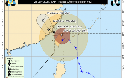
The track of Typhoon Carina (Image from PAGASA)
MANILA – The southwest monsoon or “habagat” enhanced by Typhoon Carina will continue to dampen most parts of the country, the weather bureau said Thursday.
Carina is less likely to directly bring heavy rainfall as it nears the boundary of the Philippine Area of Responsibility (PAR) and was last tracked at 465 km. north of Itbayat, Batanes, or in the vicinity of Hsinchu County, Taiwan.
It will, however, bring rains and gusty winds in Batanes.
The typhoon packs maximum sustained winds of 150 kph near the center and gustiness of up to 250 kph, moving northward at 20 kph.
The “habagat” is forecast to bring moderate to intense rainfall over various localities in the western portion of Luzon from Thursday to Saturday.
It will also cause strong to gale-force gusts in Batanes, Babuyan Islands, the Ilocos and Cordillera regions, Nueva Vizcaya, Quirino, the eastern portion of Isabela, Central Luzon, Metro Manila, Calabarzon, Mimaropa, Bicol Region, Western Visayas, Negros Occidental, and Northern Samar until Friday.
A gale warning is in effect over the coastal waters of Batanes, Babuyan Islands, Ilocos Norte, Ilocos Sur, and northwestern Cagayan.
Sea travel is risky for small seacraft, including all types of motorbancas, the Philippine Atmospheric, Geophysical and Astronomical Services Administration (PAGASA) said.
Moderate seas are also expected over the eastern seaboards of Central and Southern Luzon, the southern seaboard of Southern Luzon, the western and eastern seaboards of the Visayas, and the eastern seaboard of Mindanao.
Mariners of motorbancas and similarly-sized vessels are advised to take precautionary measures while venturing out to the sea, PAGASA said. (PNA)
