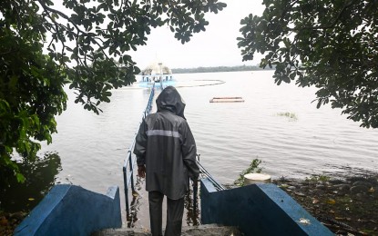
CRITICAL LEVEL. La Mesa Dam in Quezon City reaches water level of 80.03 meters as of 3 p.m. Monday (Sept. 2, 2024), near its spilling level of 80.15 meters. Water from La Mesa Dam, when released, affects low-lying areas along Tullahan Rover from Quezon City (Fairview, Forest Hills Subdivision, Quirino Highway, Sta. Quiteria, and San Bartolome), Valenzuela (North Expressway, La Huerta Subdivision), and Malabon. (PNA photo by Joan Bondoc)
MANILA – The weather bureau said La Mesa Dam's water level reached 80.03 meters as of 3 p.m. Monday and it is expected to rise further due to continuous rains.
The dam's spilling level is 80.15 meters.
The Philippine Atmospheric, Geophysical and Astronomical Services Administration (PAGASA) said this is expected to affect low-lying areas along the Tullahan River from Quezon City, Valenzuela and Malabon.
Residents of those areas, especially near the river banks, are advised to be alert against further increase of water level along the river.
Tropical Storm Enteng (Yagi) enhances the southwest monsoon, bringing heavy rains in many parts of Luzon, including Metro Manila.
Road closures due to floods
The Department of Public Works and Highways (DPWH), meanwhile, reported that three national roads are closed while seven others are open only to heavy vehicles in Calabarzon due to floods caused by Tropical Storm Enteng and the southwest monsoon.
Based on the report of agency’s Bureau of Maintenance (BOM), the impassable roads in Rizal province are the Manila East Road --Barangay San Juan in Morong, Barangay Gamo and Tandang Kutyo sections in Tanay town and Barangay Takungan and Bagumbayan sections in Pililla town; J.P. Rizal St. in Baras town; and Sagbat Pililla Diversion Road in Barangay Maybancal in Morong town.
The roads with limited access are: General Evangelista Road in Barangay Maliksi I, Bacoor City in Cavite; Imelda Avenue in Barangay Sto. Domingo, Cainta town; Cainta Kaytickling Antipolo Teresa Road in Barangay San Juan, Taytay town; Manila East Road (Taytay Bayan) in Barangay San Isidro, Taytay town; San Mateo-Rodriguez Road, Barangay Ampid, Dulong Bayan, and Maly sections in San Mateo town and Barangay Mangahan section in Montalban town; Tanay Sampaloc Road, Barangay Plaza, Aldea; and Rodriguez San Jose-Quezon City Road, Barangay San Jose, Montalban town.
Motorists are advised to avoid these flooded areas and use alternate routes.
The Manila City government, meanwhile, activated response measures amid bad weather due to Enteng.
Mayor Honey Lacuna has mobilized all of the six city-run hospitals, along with the Manila Disaster Risk Reduction Management Office (MDRRMO), the Department of Engineering and Public Works and the city’s Department of Social Welfare to assist those who are affected by the storm.
She also visited the affected areas that include Barangays 101 and 128 in Tondo, as well as Baseco and Isla Puting Bato, among others.
Families in areas that are hardest hit during typhoons were also ordered evacuated to ensure their safety.
The Department of Public Services was directed to assist the MDRRMO and the Engineering Office in clearing roads of fallen trees and other forms of obstruction that may have been caused by floods. (with Ferdinand Patinio/PNA)
