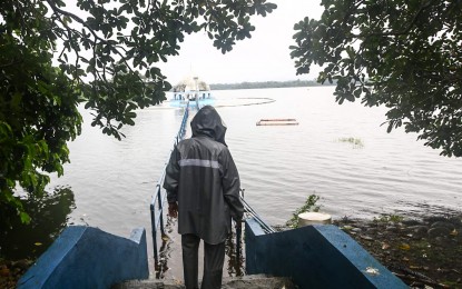
CRITICAL LEVEL. La Mesa Dam in Quezon City reaches a water level of 80.03 meters as of 3 p.m. Monday (Sept. 2, 2024), near its spilling level of 80.15 meters. Water from La Mesa Dam, when released, affects low-lying areas along Tullahan River from Quezon City (Fairview, Forest Hills Subdivision, Quirino Highway, Sta. Quiteria, and San Bartolome), Valenzuela (North Expressway, La Huerta Subdivision), and Malabon. (PNA photo by Joan Bondoc)
MANILA – Severe Tropical Storm Enteng (Yagi) left the Philippine Area of Responsibility on Wednesday but rain showers continue, causing the La Mesa Dam to overflow, the weather bureau said.
In an advisory issued at 7 a.m., the Philippine Atmospheric, Geophysical and Astronomical Services Administration (PAGASA) said the dam's water level reached 80.19 meters, breaching its spilling level of 80.15 meters.
Average basin rainfall for the past 12 hours was moderate to heavy, while the rainfall forecast for the next 12 hours is moderate to occasionally heavy.
Areas along the Tullahan River may be affected.
PAGASA advised people living near the riverbanks and low-lying areas to take appropriate actions.
Meanwhile, no tropical cyclone and signal were hoisted on any part of the country, but strong to gale-force gusts could be experienced in Ilocos Region, Abra, Benguet, Isabela Zambales, Bataan, Aurora, Bulacan, Metro Manila, Calabarzon, Mimaropa, Bicol Region, Western Visayas, Negros Island, and Northern Samar due to the enhanced southwest monsoon.
Heavy rainfall is expected in Ilocos Norte and Ilocos Sur but other areas across Luzon, especially the western section, could also experience moderate to intense rainfall due to the southwest monsoon.
Gale warning is in effect over the northern and western seaboards of Northern Luzon, and the western seaboards of Central and Southern Luzon. Sea travel is risky for small seacrafts, including all types of motor bancas.
Moderate to rough seas are expected over the remaining seaboards of Northern Luzon and the remaining western seaboard of Southern Luzon. Mariners of small seacrafts, including all types of motor bancas, are advised not to venture out to sea under these conditions, especially if inexperienced or operating ill-equipped vessels.
PAGASA added that up to moderate seas are expected over the eastern seaboard of Central and Southern Luzon, the southern seaboard of Southern Luzon, the western and eastern seaboards of the Visayas, and the eastern seaboard of Mindanao.
Mariners of motor bancas and similarly-sized vessels are advised to take precautionary measures while venturing out to sea and, if possible, avoid navigation under these conditions, PAGASA said. (PNA)
