(Photo courtesy of DPWH)
MANILA – The Philippine government and an international lender are developing comprehensive flood risk management master plans for the country's major and principal river basins.
In a statement Friday, Department of Public Works and Highways (DPWH) Senior Undersecretary Emil Sadain said the preparation of an updated master plan of three river basins under package 5B of the Asian Development Bank (ADB)-assisted Infrastructure Preparation and Innovation Facility Additional Financing for Water Projects (Output 2) are underway.
The plans were presented by the study consultants during the second meeting of the steering committee, chaired by Sadain, on Sept. 11.
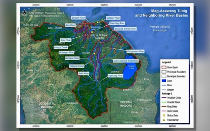
The projects involved are the Mag-Asawang Tubig and neighboring basins in the provinces of Oriental and Occidental Mindoro in Mimaropa; Agno River that originates from the central mountain range of Cordillera with its river system and tributaries extending to Benguet, Mountain Province, and Ifugao in the Cordillera Administrative Region, Pangasinan in Ilocos Region, Nueva Vizcaya in Cagayan Valley, and partly Tarlac, Nueva Ecija, Pampanga and Zambales in Central Luzon; and the Cadac-an River Basin in Leyte in Eastern Visayas.
“In line with the directive of President Ferdinand R. Marcos Jr. and the policy instruction of Secretary (Manuel) Bonoan, the master plans being prepared will not only provide a strategic and long-term approach to flood risk management but also have to be integrated with the other sectors to conserve and utilize the water beneficially like for irrigation, water supply and power,” Sadain said.
The study, which focuses on areas most vulnerable to severe flooding, lays the groundwork for future flood control infrastructure investments, ensuring that these projects are cost-effective and systematically planned in enhancing disaster resilience and improving water management.
Among the areas being studied, the Agno River Basin, the fifth largest river systems with a catchment area of 5,937 square km and river length of 206 km, presents significant flood risks for low-lying provinces like Pangasinan and Tarlac during heavy rains because of insufficient current flood control structures designed and completed beyond the returned year period of flooding.
In Mindoro provinces, the Mag-Asawang Tubig and neighboring river basins pose threats to agricultural zones and coastal towns due to heavy siltation of waterways and bank erosion, while Leyte’s Cadac-an River Basin remains highly vulnerable to tropical cyclones because of its small discharge capacity.
The updates aim to incorporate climate projections, urbanization, land use changes, and population growth trends to address emerging challenges effectively.
Once completed, these master plans will be integral to the national flood control strategy.
These will also underpin long-term flood risk and water resources management efforts, aligning with the government’s Build Better More program to promote inclusive development and enhance disaster risk reduction.
The DPWH Unified Project Management Office-Flood Control Management Cluster, along with consultants from Saman Corporation, Royal Haskoning DHV, Dohwa Engineering Company Ltd., and Kyong-Ho Engineering, is working closely with local government units, national agencies, and development partners to ensure a comprehensive assessment of flood risks and vulnerabilities for each river basin.
Given the unique geographical, hydrological, and environmental conditions, the DPWH has chosen to develop independent master plans for each of the 18 major river basins and 421 other principal river tributaries.
These master plans are being updated with the support from the ADB, Japan International Cooperation Agency and Export-Import Bank of Korea. (Ferdinand Patinio/PNA)
