(Image courtesy of PAGASA/DOST)
MANILA – A low pressure area (LPA) inside the Philippine Area of Responsibility (PAR) has developed into a tropical depression named “Gener” as several areas in Luzon are placed under Tropical Cyclone Wind Signal No. 1, the weather bureau said Monday.
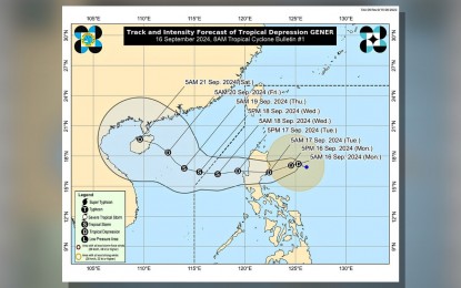
The Philippine Atmospheric, Geophysical and Astronomical Services Administration (PAGASA) said as of 8 a.m., Gener is located 315 kilometers northeast of Casiguran, Aurora with maximum sustained winds of 45 km. per hour near the center and wind gusts of up to 55 kph while moving west at 10 kph.
“The tropical depression is forecast to move generally west to west southwest until Wednesday afternoon before turning west northwestward to northwestward for the rest of the forecast period,” PAGASA said.
Gener is expected to make landfall on either Isabela or Aurora province within the next 24 hours and may exit the PAR by Wednesday.
“Gener is likely to experience limited intensification over the next two days but is expected to reach Tropical Storm category by Wednesday after emerging over the West Philippine Sea,” the weather bureau said.
Tropical Cyclone Wind Signal (TCWS) No. 1 is hoisted over the eastern and central portions of mainland Cagayan (Piat, Santo Niño, Camalaniugan, Tuao, Lal-Lo, Enrile, Gonzaga, Alcala, Amulung, Santa Teresita, Baggao, Buguey, Solana, Rizal, Santa Ana, Tuguegarao City, Gattaran, Peñablanca, Iguig, Lasam, Aparri, Ballesteros, Allacapan, Abulug), Isabela, Quirino, and the eastern portion of Nueva Vizcaya (Alfonso Castaneda, Kasibu, Dupax del Norte, Quezon, Diadi, Bayombong, Ambaguio, Bagabag, Villaverde, Aritao, Bambang, Dupax del Sur, Solano).
The eastern and southern portions of Apayao (Conner, Flora, Pudtol, Santa Marcela, Luna, Kabugao), Kalinga, the eastern and central portions of Mountain Province (Paracelis, Sadanga, Bontoc, Natonin, Sabangan, Barlig), Ifugao, Aurora, the eastern portion of Nueva Ecija (Carranglan, Pantabangan, Bongabon, Gabaldon, Laur, General Tinio, Rizal, General Mamerto Natividad, Palayan City), and the northern portion of Mainland Quezon (General Nakar, Infanta, Real) including Polillo Islands are also under TCWS No. 1.
“Minimal to minor impacts from strong winds are possible within any of the areas under Wind Signal No. 1,” PAGASA said.
Gener and a tropical storm with international name “Pulasan” outside PAR will enhance the southwest monsoon or habagat and will affect Mimaropa, Bicol Region, Visayas, Zamboanga Peninsula, Northern Mindanao and Davao Region, PAGASA said.
“Gale warning is in effect over the western and southern seaboards of southern Luzon, the seaboards of Visayas, and the western, northern, and eastern seaboards of Mindanao. Sea travel is risky for small seacrafts, including all types of motor bancas,” PAGASA said. (PNA)
