(Courtesy of PAGASA)
MANILA – Scattered rains are forecast in northern Luzon, while some areas have been placed under Tropical Cyclone Wind Signal No. 1 due to Tropical Depression Julian, the weather bureau said Friday afternoon.
Julian maintained its strength, packing maximum sustained winds of 55 kph near the center and gustiness of up to 70 kph.
It could reach the tropical storm category either Friday night or Saturday.
The TD was last located 425 kilometers east of Basco, Batanes.
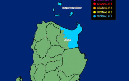
Strong winds will be experienced in areas under Signal No. 1: Babuyan Islands and the eastern portion of mainland Cagayan (Santa Ana, Gonzaga, Gattaran, Lal-Lo, Baggao, Buguey, Aparri, Santa Teresita, Camalaniugan, Peñablanca, Ballesteros)
The Philippine Atmospheric, Geophysical and Astronomical Services Administration said Julian will also cause scattered rains and thunderstorms in Ilocos Norte, Ilocos Sur, Abra, Apayao, Kalinga, Mt. Province, Batanes, Cagayan and Isabela.
The rest of the country will experience isolated rain showers due to localized thunderstorms.
Meanwhile, moderate to strong winds and moderate to rough seas are forecast to prevail across Northern Luzon.
Elsewhere, winds will be light to moderate with slight to moderate seas. (PNA)
