(Image courtesy of PAGASA)
MANILA – Signal No. 1 is hoisted over three areas as Tropical Depression Julian maintains its strength while decelerating over the Philippine Sea.
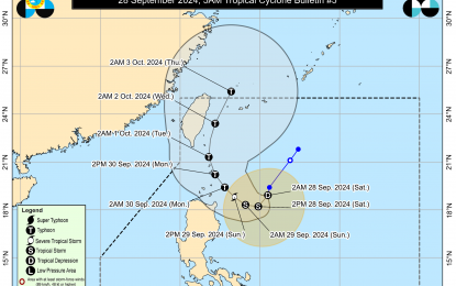
As of 3 a.m. Saturday, Julian was estimated at 430 km. east of Calayan, Cagayan, or 410 km. east of Aparri, Cagayan, with maximum sustained winds of 55 kph near the center, gustiness of up to 70 kph., and moving southward at 10 kph.
Signal No. 1 is hoisted over Cagayan, including the Babuyan Islands; the northeastern portion of Isabela (San Pablo, Divilacan, Maconacon, Palanan, Cabagan, Santa Maria, Tumauini, Ilagan City, San Mariano, Santo Tomas, and Delfin Albano); and the eastern portion of Apayao (Luna, Pudtol, Santa Marcela, and Flora).
Julian will continue to intensify and may reach tropical storm category Saturday afternoon, and reach typhoon category by Monday, according to the Philippine Atmospheric, Geophysical and Astronomical Services Administration (PAGASA).
PAGASA said Julian may make landfall over Batanes by Monday afternoon or evening as a typhoon and may exit the Philippine Area of Responsibility by Wednesday (Oct. 2) evening to Thursday (Oct. 3) early morning.
It is forecast to follow a looping path over the waters east of Batanes and Cagayan, moving southwestward before turning westward Saturday afternoon while decelerating.
It will then move generally northwestward from Sunday until Tuesday before turning northward to north-northeastward for the remaining of the forecast period.
Rains with gusty winds are expected over Cagayan, including the Babuyan Islands.
Meanwhile, Ilocos Norte, Ilocos Sur, Abra, Apayao, Kalinga, Mountain Province, Ifugao, Batanes, and Isabela will experience cloudy skies with scattered rains and thunderstorms due to the effects of Julian.
Metro Manila and the rest of the country will have partly cloudy to cloudy skies with isolated rain showers or thunderstorms due to localized thunderstorms.
Moderate to strong winds and moderate to rough coastal waters will be felt over Northern Luzon, while the rest of the archipelago will have light to moderate winds and slight to moderate seas. (PNA)
