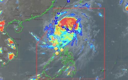
Track of Typhoon Julian (Satellite image courtesy of PAGASA-DOST)
MANILA – Typhoon Julian maintained its strengthen while moving northwestward over the Philippine Sea east of Cagayan, the Philippine Atmospheric, Geophysical and Astronomical Services Administration (PAGASA) said in its 5 p.m. bulletin Sunday.
The center of the typhoon is located 235 kilometers east of Calayan, Cagayan while moving westward at 15 kph with maximum sustained winds of 120 kph near the center ang gustiness of up to 150 kph.
Julian is forecast to continue intensifying over the next 24 to 36 hours as it moves towards Batanes and/or Babuyan Islands.
PAGASA hoisted Tropical Cyclone Wind Signal (TCWS) No. 3 over Batanes and the northeastern portion of Babuyan Islands.
Areas under TCWS No. 2 are Mainland Cagayan, the rest of Babuyan Islands (Camiguin Is., Calayan Is., Dalupiri Is., Fuga Is.), Apayao, and the northern and central portions of Ilocos Norte (Pagudpud, Adams, Dumalneg, Bangui, Burgos, Pasuquin, Vintar, Carasi, Nueva Era, Solsona, Piddig, Dingras, Sarrat, San Nicolas, Laoag City, Bacarra).
The rest of Ilocos Norte, Ilocos Sur, La Union, Abra, Kalinga, Ifugao, Mountain Province, Benguet, Isabela, Nueva Vizcaya, Quirino, and the northern and central portions of Aurora (Dilasag, Casiguran, Dinalungan, Dipaculao) are under TCWS No. 2.
The weather bureau said areas under TCWS No. 3 might experience moderate to significant impacts from storm-force winds.
“A gale warning is hoisted over the northern and eastern seaboards of Northern Luzon. Sea travel is risky for small seacrafts, including all types of motor bancas,” PAGASA said.
Batanes, Babuyan Islands and Ilocos Norte will experience intense to torrential rains while mainland Cagayan, Ilocos Sur and Abra will have heavy to intense rains in the next 24 hours, PAGASA added. (PNA)
