STILL STRONG. Batanes remains under tropical cyclone wind signal (TCWS) No. 4 even as Typhoon Julian heads out of the island, the Philippine Atmospheric, Geophysical and Astronomical Services Administration said on its 5 p.m. bulletin. Julian is forecast to intensify into super typhoon Monday night and exits the Philippine Area of Responsibility by Thursday (Oct. 3, 2024) (Photo grabbed from PAGASA’s Facebook page)
MANILA – Tropical cyclone wind signal (TCWS) no. 4 remains hoisted over Batanes even if Typhoon Julian is now moving away from the island, the state weather bureau said Monday afternoon.
Julian was last tracked 95 km. west southwest of Itbayat, Batanes, heading the northwestern boundary of the Philippine Area of Responsibility.
The typhoon packs maximum sustained winds of 175 kph near the center, and gustiness of up to 215 kph.
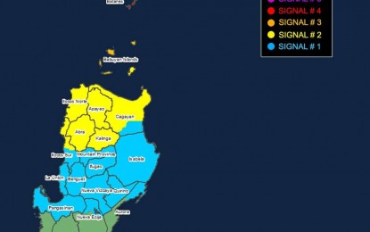
Typhoon-force winds will continue to prevail in Batanes, while storm-force winds will continue in areas under TCWS no. 3, which covers the northern and western portions of Babuyan Islands (Babuyan, Calayan, Dalupiri, Fuga islands).
TCWS no. 2 has been hoisted over northern and westwern portion of mainland Cagayan (Piat, Santo Nino, Camalaniugan, Tuao, Lal-Lo, Pamplona, Gonzaga, Alcala, Amulung, Santa Teresita, Baggao, Buguey, Solana, Rizal, Claveria, Gattaran, Iguig, Lasam, Aparri, Ballesteros, Abulug, Allacapan, Sanchez-Mira, Santa Praxedes, Santa Ana).
Also, the rest of Babuyan Islands, Apayao, Abra, Kalinga, Ilocos Norte, and the northern and central portions of Ilocos Sur (Sinait, Cabugao, San Emilio, Lidlidda, Banayoyo, Santiago, Santa Maria, Burgos, San Esteban, Nagbukel, Narvacan, Santa, Caoayan, Bantay, Santo Domingo, San Juan, San Vicente, San Ildefonso, Magsingal, Santa Catalina, City of Vigan). These areas will experience gale-force winds.
Strong winds remain likely in areas under TCWS no. 1, Ilocos Sur, La Union, Pangasinan, Ifugao, Mountain Province, Benguet, the rest of mainland Cagayan (Peñablanca, Tuguegarao City, Enrile), Isabela, Nueva Vizcaya, Quirino, the northern portion of Aurora (Dilasag, Casiguran, Dinalungan), and the northern portion of Nueva Ecija (Carranglan, Lupao, Pantabangan).
Strong to gale-force gusts are still forecast in Aurora, Zambales, Bataan, Metro Manila, Calabarzon, Romblon, and Bicol Region, the Philippine Atmospheric, Geophysical and Astronomical Services Administration (PAGASA) said.
Meanwhile, PAGASA said there is a moderate to high risk of life-threatening storm surge in the next 48 hours over the low-lying or exposed coastal localities of Batanes, Cagayan, and Ilocos Norte.
Gale warning is hoisted over the seaboards of Northern Luzon. Sea travel is risky all types or tonnage of vessels.
Julian could reach the super typhoon category tonight as it continues to intensify, but is forecast to exit PAR on Thursday, PAGASA added. (PNA)
