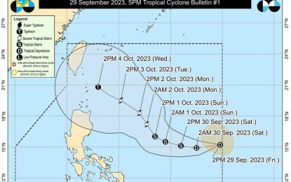
Track of Tropical Depression Jenny (DOST-PAGASA Facebook page)
MANILA – The low pressure area (LPA) being monitored by the weather bureau entered the Philippine Area of Responsibility (PAR) and developed into a tropical depression named Jenny, the weather bureau said on Friday.
Packing maximum sustained winds of 45 kph near the center, and gustiness of up to 55 kph. Jenny was last tracked 1,400 km. east of southeastern Luzon.
The Philippine Atmospheric, Geophysical and Astronomical Services Administration (PAGASA) said Jenny would not directly affect any part of the country.
A close approach over the Batanes area is possible by Wednesday. A landfall scenario over Batanes-Babuyan or northeastern mainland Cagayan is also not ruled out.
Heavy rainfall is forecast over Batanes and Babuyan Islands in the next five days.
The hoisting of tropical cyclone wind signals in some areas in Northern Luzon could begin on Sunday.
Meanwhile, Jenny could cause moderate to rough seas over the coastal waters of extreme Northern Luzon and the northeastern portion of mainland Cagayan.
PAGASA advised operators of motor bancas and similarly-sized vessels to avoid navigating in these conditions. (PNA)
