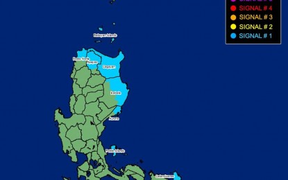
Areas under Tropical Cyclone Wind Signal 1 and 2 in Luzon (From PAGASA Facebook page)
MANILA – Tropical cyclone wind signal (TCWS) no. 2 is now hoisted over several areas in Batanes as Typhoon Carina slightly intensifies, the weather bureau said Tuesday.
In its 11 a.m. update, the Philippine Atmospheric, Geophysical and Astronomical Services Administration (PAGASA) said Carina packs maximum sustained winds of 140 km. per hour near the center and gustiness of up to 170 kph.
The typhoon was last tracked 320 km. east of Basco, Batanes or 405 km. east northeast of Aparri, Cagayan.
Areas under TCWS no. 2 are Itbayat, Basco, Mahatao, Uyugan and Ivana which will experience gale-force winds, while areas under TCWS no. 1 -- the rest of Batanes (Sabtang), Cagayan including Babuyan Islands, the eastern portion of Isabela (Divilacan, Palanan, Maconacon, Dinapigue, Tumauini, Ilagan City, San Mariano, Cabagan, San Pablo, Santa Maria), the northern portion of Apayao (Calanasan, Luna, Pudtol, Flora, Santa Marcela), the northern portion of Ilocos Norte (Pagudpud, Bangui, Adams, Dumalneg, Burgos, Vintar), the northern portion of Aurora (Dilasag, Casiguran), Polillo Islands, Calaguas Islands, and the northern portion of Catanduanes (Pandan, Bagamanoc, Panganiban, Viga, Gigmoto, Caramoran) --will experience strong winds.
Carina also enhances the southwest monsoon (habagat) which will bring moderate to intense rainfall over various localities in the western portion of Luzon.
Gale-force gusts due to the southwest monsoon will also be experienced in Ilocos Region, Abra, Benguet, Nueva Vizcaya, Quirino, Zambales, Bataan, Aurora, Metro Manila, Calabarzon, Mimaropa, Bicol Region, Visayas, Zamboanga Peninsula, Northern Mindanao, and Davao Region.
Meanwhile, PAGASA maintained that Carina will remain far from landmass.
The typhoon is forecast to make landfall over the northern portion of Taiwan between Wednesday night and Thursday, and exit the Philippine Area of Responsibility after some hours.
Heavy rains cause floods in NCR
Seven road sections in four cities in Metro Manila are flooded due to heavy rains and passable only to heavy vehicles, according to the Department of Public Works and Highways (DPWH).
As of Tuesday noon, the DPWH said the flooded areas in the cities are Mandaluyong, Manila, Pasay and Quezon.
In Mandaluyong City, the flooded areas are Boni Avenue, cor. F. Ortigas and Boni Avenue, Maysilo Circle with a depth of 30 cm.
In Manila, flooded areas include the Blumentritt Road cor. P. Margal and P. Florentino (20 cm. deep) and Mel Lopez Boulevard cor. C2 and Moriones (10 cm. deep).
In Pasay City, two roads are flooded -- Taft Avenue northbound near Arellano University (5 cm.) and EDSA cor. Taft Avenue (10 cm.)
In Quezon City, floods at the Elliptical Road near cor. Quezon Avenue have a depth of 20 cm. (with report from Ferdinand Patinio/PNA)
